Current PhD research

Climatic cyclicity and environmental interactions in arid continental basins: The Leman Sandstone, Southern North Sea
Supervisory Team: Dr Stuart M. Clarke, Dr Phil Richards (British Geological Survey) and Dr Tom Randles (British Geological Survey)
Funding: NERC CDT in Oil and Gas
 The project will evaluate the interactions and controlling mechanisms affecting linked ephemeral fluvial, playa and aeolian systems in outcrop and a sub-surface North Sea analogue. It will elucidate the relative impacts of climate change and tectonism on facies distributions and interactions in these systems, and provide a three-dimensional fluid-flow model pertinent to migration and reservoir evaluation.
The Leman Sandstone comprises a sedimentary succession recording the interaction between ephemeral fluvial systems, aeolian and playa environments. The record is punctuated by numerous regional surfaces, the origin of which may have been mostly climatic, with periods of increased run-off resulting in fluvial incision, especially near active faults.
However, the surfaces formed in a basin that was actively subsiding. Thus, even in a background of overall increasing accommodation space, climatic variation may have allowed for periods of significant erosion. The occurrence of significant erosion resulted in a sedimentary record that shows pronounced lateral as well as vertical facies variations. The distribution of facies element geometries, their three-dimensional interactions and relationships to regional erosive surfaces, and their dependence on climatic variation and active tectonism, are critical to understanding the distribution of petrophysical properties within the Leman Sandstone, and therefore to the distribution of fluid migration pathways for reservoir characterisation and management.
Interactions between fluvial and aeolian systems in arid continental basins have been the subject of past research (e.g. Mountney & Jagger 2004), and these relationships have been related to a sequence-stratigraphical framework based upon climatic cyclicity. However, this past work does not account for a fluvial component that is strongly ephemeral, and upon which there is a strong control on facies distribution from active tectonism. North & Taylor (1996), and the present authors, have shown that in strongly ephemeral-fluvial systems elements show significantly more variability at all scales. Hence the distribution of ephemeral-fluvial deposits, and their interaction with other environments, will more strongly control permeability distributions and migration pathways than is the case for more stable fluvial settings.
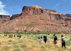
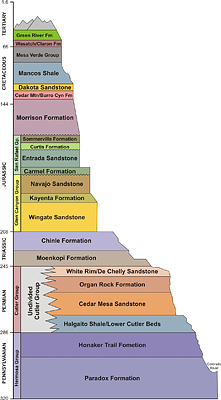
This work will use well-exposed sedimentary successions through arid continental depositional systems within the intra-cratonic basins of the Western USA, principally the Wingate, Moenave and Kayenta formations of the Colorado Plateau, to provide a well-constrained analogue for environmental interaction and facies distribution within the Leman Sandstone.
The work will use outcrop to address three issues specifically: 1) The local-scale interactions between ephemeral-fluvial, playa and aeolian environments at times of differing relative dominance, 2) the regional-scale variations that climatic cyclicity impose upon the evolving system, and 3) the controls of active tectonism at a variety of scales.
To these ends, the project will:
- Use logging, two-dimensional panel construction and digital field capture techniques to examine and record in detail the spatial interaction and geometry of architectural elements and facies distributions of the aeolian, playa and ephemeral fluvial environments where they are coeval and interact.Develop three-dimensional models of sedimentary interactions between elements of these environments, and their dependence upon climate.
- Use logging techniques to produce detailed sedimentary logs at key points along regional-scale transects from the ephemeral-fluvial environment through the coeval erg margin and into the erg centre, and temporally through the evolution of the environment from Wingate to Kayenta times.
- Analyse these logs for wetting and drying upward cycles, and chronostratigraphically significant fluvial erosion and aeolian deflation surfaces to correlate climatic cycles from the ephemeral fluvial environment through the erg margin to the erg centre, develop a sequence-stratigraphical framework, and relate the large-scale evolution of the arid depositional system to climatic cyclicity.
- Examine the three-dimensional relationships between actively evolving faults and the distribution of facies from the coeval environments at a variety of scales, and develop summary models of these interactions.
From these analyses the project will:
- Use three-dimensional models of facies interactions, coupled with their dependence on regional climatic cyclicity and localised active tectonism, to provide control on the evolution of the Leman Sandstone, the development of significant erosive surfaces, facies distribution and petrophysical properties at a variety of scales.
- Demonstrate the generic effects on potential flow pathways of sedimentary variation within ephemeral-aeolian-playa environments using stochastic migration modelling techniques.
The influence of halokinesis on shallow-marine sediments in salt basins: The Fulmar Formation, Central North Sea, UK
Supervisory Team: Dr Ian Stimpson, Keele University; Dr S. Banham, British Geological Survey; S. Rogers, Keele University
Overview
The Upper Jurassic Fulmar Formation hosts significant accumulations of hydrocarbons across the central North Sea, with currently over sixty discoveries and developments within this single play. Despite this success, the number of exploration wells targeting Fulmar plays is decreasing, despite ample opportunities for continued exploration. The Fulmar sediments accumulated within Late Jurassic salt-collapse basins, formed by dissolution of mobile Zechstein salt walls. However, the genesis of the play is complicated, as the formation of an economic reservoir requires a carefully balanced rate of sediment supply and salt-wall dissolution: if the rate of sediment supply compared to that of subsidence is too low, the basin may be filled with deep-water fine-grained sediment, but if the rate of sediment supply is too high, sediment may be scoured from the basin during sediment bypass.
Methodology
This project will investigate the influence of halokinesis upon the sedimentology of the Fulmar Formation by examining the temporal and spatial distribution of facies between the collapse basins across the Central North Sea, and their relationship to the magnitude of salt dissolution (subsidence rate), relative sediment input rates and, where possible, the timing of basin formation. From these analyses, the project will construct depositional models that describe the likely depositional environments and distribution of facies, both within the Jurassic collapse-basins and between them. In so doing, the work will elucidate the relative influence of sediment supply, halokinesis and subsidence upon facies distribution, and produce predictive models of likely reservoir distribution, quality and connectivity that are applicable to the Fulmar Formation and similar salt-influenced shallow-marine sediment hydrocarbon plays.
The project will focus primarily on the study of core and wireline data from well penetrations of the Fulmar Formation and associated stratigraphy, and 3D seismic data collected from across the Central North Sea, to examine the nature and to constrain the lateral extent of the Fulmar within the collapse basins. Typically, where field development has taken place, multiple close-spaced wells penetrate the Fulmar Formation, providing a level of spatial coverage that will allow detailed observation of lateral facies variations within a single collapse basin. To supplement this desk-based study, a single field season to observe shallow marine-halokinetic interactions will constrain lateral facies variations and the relationship of architectural elements within the depositional system. Likely candidate field areas include: La Popa Basin, Mexico; Wonoka Formation, Australia; Mississippi delta.
Previous PhD Research
Project title: The geometry and distribution of thrust-fold-related fractures in limestones: implications for the hydrocarbon prospectivity of the Potwar fold belt, N Pakistan
Carbonate reservoirs host some of the biggest hydrocarbon discoveries worldwide. However, reservoir quality and prospectivity in carbonates is commonly a function of porosity and permeability provided by secondary (post-depositional) characteristics, such as fractures (right), rather than the primary (depositional) characteristics of the matrix. Without the presence of fractures, many carbonates are tight to both oil and gas and do not typically host viable fields. Consequently, the structural geological history of carbonates is an important factor in governing their future reservoir potential. Post-depositional shortening by thin-skinned thrusting produces characteristic fold styles within thrusted blocks that host spectacular fracture networks, thus dramatically increasing reservoir potential.
This project will use high quality field outcrops to define fracture characteristics in folded limestones for fold geometries related to thin-skinned thrust tectonics. Those data will be used to develop generic models of fold-related fractures to provide input for reservoir simulation in thrust-fold-related carbonate reservoirs. The work will be applied to a series of proven hydrocarbon fields in the Potwar Basin of the Pakistani Himalayan foreland where thrust-related anticlines host reservoirs within fractured carbonate rocks.
Project title: The development of lake margins, their interactions with contemporaneous continental environments and the implications for their reservoir potential
The interiors of continental sedimentary basins are typically characterised by enclosed lakes, and associated lacustrine depositional systems, that provide the ultimate sink for sediment transported through the basin. Lacustrine sediments have the potential to form excellent hydrocarbon source rocks, and lacustrine margins may develop significant deposits of sand-grade sediment with good reservoir potential. However, despite this well-recognised hydrocarbon potential, the characteristics of lacustrine shoreline sediments, their relationships to lake type and development, their interactions with lake-marginal continental sedimentary environments, and the relations between their reservoir potential and their evolution remain somewhat equivocal.
Using a combination of outcrop, seismic and core data, this project will examine a range of lakes of different sizes and styles, developed in icehouse and greenhouse climatic settings, and in a range of tectonically and non-tectonically-controlled basins, in order to develop a suite of models that typify the range of lake-shoreline sediments, their reservoir potential and their relations to the depositions of lacustrine source rocks. The project will relate these models to the controls of sediment supply, water level, accommodation and climate upon lake evolution, and provide field-based analogue models to aid future petroleum exploration in lacustrine depositional systems.
Project title: Structural, stratigraphic and geodynamic controls on the evolution of the Carboniferous succession of northern England and southern Scotland
Supervisored by: Dr Stuart Egan, Dr Stuart M. Clarke and Graham Leslie.
The structural and geodynamic processes that have controlled the evolution of the Carboniferous basin system of northern England and southern Scotland, as well as interactions with the neighbouring North Sea, are very poorly understood. As a consequence, correlations of sedimentary fill, and sequence stratigraphical controls upon them, remain elusive.
The main aim of this project will be to apply and further develop 3D lithosphere-scale tectonic modelling techniques in order to determine the interplay of geological and geodynamic processes that have controlled the evolution of the Carboniferous succession within the Northumberland Trough, Solway Basin, Stainmore Trough, Vale of Eden Basin and Midland Valley, as well as their offshore extensions and intervening areas of relative uplift such as the Alston Block, which contain large granitic intrusions within the pre-Carboniferous basement.
The models will be constrained by regional-scale cross-sections constructed from the BGS database and the public domain, with selected profiles sequentially restored to provide a “snapshot” of structural and stratigraphical architecture during the Carboniferous Period. Further constraint will be provided by the wealth of subsurface mining-related sedimentary data, combined with the field acquisition of structural data.
The study will provide insights into the importance of deep processes, such as depth-dependent extension, and how they interact with basin-controlling processes, such as bathymetry and sedimentary infill, within intra-continental, ‘basin and block’ settings.
In particular, model results will provide insights into the development of accommodation space through time in response to sea level, tectonics and sediment supply, providing a structural and geodynamic framework for the sequence stratigraphical interpretation of the Carboniferous succession within this relatively poorly understood basin system.
Andrew Mitten
Project title: Sedimentology and sequence stratigraphy in fluvial systems
Fluvial sandstones create some of the highest net to gross clastic reservoirs in the world but the quality of these reservoirs, and recovery from them, are strongly controlled by depositional style. However, the internal architecture of fluvial sandbodies is difficult to ascertain from down-hole data alone, and the rapid spatial and temporal variations in lithofacies make inter-well correlation of fluvial strata notoriously difficult (Bridge and Tye 2000). This study aims to understand the complex nature of sandbody architecture within a high net to gross fluvial reservoir, by using an integrated approach with photogrammetry, pseudo-well log and petrographic data
The study area chosen to address such issues is the Book Cliffs, Wastach Plateau and Gunnison Plateau, Utah, USA. The formations to be examined are the Lower and Upper Castlegate Sandstone and the Bluecastle Tongue. The successions are large in spatial extent and preserve around two million years of stratigraphy. The successions have previously established sequence stratigraphical models applied to them, however, there are significant discrepancies within these models. This is due to purely sedimentological study with very little in the way of an integrated approach being undertaken. Such limitations have handicapped interpretations of key surfaces and not allowed the previous works to come up with a universal model to fit the succession. This opens a niche for the project, applying a more integrated approach to the analysis of the Castlegate succession may increase the resolution of a certain model or produce a new model-independent structure all together, for high net to gross fluvial settings.
David Cousins
Controls upon facies distribution and cyclicity in aeolian systems: Implications for successful exploration and development in a mature North Sea basin
Supervisory Team: Dr Stuart M. Clarke, Dr Steven Rogers and Prof. Phil Richards
Project description
This project will evaluate the interactions and controlling mechanisms affecting aeolian systems in Permian sandstones of the southern North Sea and in well-exposed analogue outcrops. It will elucidate the relative impacts of climate, tectonism and sediment supply on facies distributions and interactions at a variety of scales, and provide a 3D fluid-flow model pertinent to migration and reservoir evaluation. Aeolian systems exhibit a range of geomorphologies each characterised by recognisable facies assemblages. The dominance and interplay of different geomorphologies is attributed primarily to sediment supply, a function, in part, of climate. It is generally accepted that deserts become ‘dryer’ towards the interior, with increased sediment supply that promotes a dominance of duneforms, and increases bedform scale and 3D complexity. Onto this distribution are superimposed the effects of climate. These patterns are recognisable in modern deserts, and many workers have observed similar patterns in ancient systems. However, preliminary studies of the aeolian Navajo Formation of the Paradox Basin, USA (present authors) have noted preservation of significant successions of anomalously ‘wetter’ sediments towards the basin interior: a direct contradiction to accepted patterns. Blakey (1994) suggests that renewed uplift of the Paradox Basin margin around Navajo times may have prompted local climatic changes. Consequently, the influences of local tectonics upon climate and sediment supply cannot be disregarded as factors governing the nature, accumulation and preservation of sediments. Others (e.g. Blair et al., 1988) have suggested that uplift of basin margins may cause an initial reduction in
sediment to the basin as the transport pathway equilibrates, giving the impression of ‘wetter’ conditions, irrespective of climate. The controls remain equivocal, but it is evident that aeolian systems have the potential to preserve significantly anomalous sedimentary successions that seriously influence reservoir quality.
This study will investigate the effects and relative importance of climate, tectonics and sediment supply at a variety of scales upon sedimentology, interactions, complexity and reservoir quality. Detailed sedimentological evaluation of the Permian sandstones on the UK Continental Shelf, in comparison with the Navajo Formation, will facilitate the development of a regional 3D model of Permian sand development. As well as traditional methods of data gathering and analysis in the field, the project will make use of novel and developing 3D photogrammetric techniques to provide spatially accurate 3D models of the outcrop. The fieldwork will provide a well-constrained analogue for facies distribution within Permian sandstone reservoirs of the North Sea, which are undergoing a resurgence of successful exploration activity at present.
The Cretaceous reservoir evolution of the south east Mesopotamian Basin, south-eastern: Geological Modelling evaluation
Supervisory Team: Dr Stuart M. Clarke and Dr Stuart Egan
Funding: Shell
Project description
Initial research will place emphasis on a general regional overview of the geodynamics, tectonics, sedimentation and hydrocarbon prospectivity of the South East part of Mesopotamian Basin. This investigation will underpin a more detailed basin analysis study, including focus on a specific area to make a detailed 3-D geological and geodynamic model.
Evaporitic/Clastic interactions in arid continental environments: Implications for reservoir quality, characterisation and fluid flow
Supervisory Team: Dr Stuart Clarke (Keele)
Project description
The interactions between competing arid continental environments exert strong controls on the sediments deposited, their preservation, and lithofacies connectivity in the subsurface. They strongly influence basin-wide fluid migration, along with reservoir-scale character, petrophysical properties and production behaviour. Clastic settings, such as alluvial-fan, fluvial and aeolian environments, and their interactions, are driven principally by physical processes and larger scale allocyclic (external) controls of climatic variation and sediment supply. The preserved lithofacies can be understood in these terms. In evaporitic systems, sediment supply and ‘deposition’ (precipitation) are strongly governed by the chemistry of the system, in addition to physical factors. Consequently, where evaporitic and clastic continental environments coexist and interact, the lithofacies preserved, and their subsurface connectively, are determined by a complex and poorly-understood interplay between 1) the physical process of the clastic systems and allocyclic controls upon them, 2) the chemical variation within the evaporitic system and the allocyclic controls upon it and, importantly, 3) the controls of the clastic system upon water and sediment supply to the evaporitic environment (interactions between systems).
This work will use field examples of modern and ancient systems from the Western USA, the UK and southern Europe, to examine and interpret clastic/evaporitic interactions, their preservation potential, and subsurface connectivity of lithofacies. The work will develop quantified facies models in both space and time that predict lithofacies distribution, net-to-gross, reservoir quality and subsurface interconnectivity in mixed clastic / evaporitic systems. These models will be applied to detailed core and subsurface data from the Permo-Triassic strata of the onshore UK to elucidate the effects of climate and sediment supply upon larger-scale facies distribution. In so doing, it will develop a cyclo-stratigraphic framework that predicts lithofacies connectivity in mixed clastic and evaporitic settings. The results of these two scales of investigation will be applied to reservoir examples from the Permian strata of the Southern North Sea (SNS) to provide further insight for reservoir management and enhanced recovery.
Sedimentary controls on secondary processes: Deformation bands in reservoirs
Supervisory Team: Dr Ian Stimpson (Keele) and Dr Oliver J.W. Wakefield (British Geological Survey)
Funding: NERC CDT in Oil and Gas
Project description
The type and distribution of lithofacies, borne of primary sedimentological processes, has a direct control on the physical properties of sediment bodies, and it is therefore unsurprising that facies distributions exert some control on the development and distribution of small-scale structures, such as deformation bands, which are the main deformation element of fault zones in porous sandstones [1].
The relationships between deformation bands and larger scale faults have been well documented [2] as have relationships to bulk lithology [3], but little attention has been given to controls on deformation band formation by depositional processes and facies directly. Preliminary field observations, by the present authors indicate that structural deformation bands occur preferentially within clean, aeolian sandstones, and less so in more immature (but good reservoir) fluvial facies subject to the same regional and local stresses. However, the structures and exact geometries that these deformation bands inhabit, and their relationships to lithofacies, are poorly understood.
This project undertakes a detailed field campaign using the well-exposed, mixed aeolian-fluvial Sherwood Sandstone Group (SSG) of the Cheshire Basin as a principal case study, with additional fieldwork in Utah, USA, using the Kayenta formation which provides a well-studied site for comparison. The SSG contains a full range of aeolian and fluvial facies types and, crucially, is well exposed in a range of outcrops that allow a three-dimensional insight. Its importance in the Cheshire basin is highlighted by continued research as an oil reservoir, with the Bowland shale as its source, as well as shale gas, an anologue to the East Irish sea and North Sea basins, and more recently has been highlighted for its potential as a low enthalpy geothermal resource [4].
Data collection will be used to create a detailed sedimentological framework that will establish the geometries and distribution of both aeolian and fluvial facies types. This framework will be used to construct models that detail i) the occurrences, geometries and connectedness of deformation bands, and, ii) porosity and permeability data of both deformation bands and lithofacies (using a field permeameter and lab analysis).
I will develop generic models of possible lithofacies control(s) on deformation bands, and deformation styles. Additionally, poro-perm data combined with detailed petrographic work will be used to identify potential impacts to reservoir quality in three-dimensions resulting from a range of deformation geometries and any anisotropy associated with such assemblages. The results from this completed project could therefore be used to better highlight lithofacies types that are more or less susceptible to deformation band formation and as such, address aspects of reservoir management.
[1] Fossen, H., et al. 2007. Deformation bands in sandstone: a review. Journal of the Geological Society 164(4): 755-769.
[2] Kolyukhin, D., Schueller, S., Espedal, M.S. & Fossen, H. 2010. Deformation band populations in fault damage zone—impact on fluid flow. Computational Geosciences, 14, 231-248.
[3] Pittman, E.D. 1981. Effect of fault-related granulation on porosity and permeability of quartz sandstones, Simpson Group (Ordovician), Oklahoma. AAPG bulletin, 65, 2381-2387.
[4] Hirst, C. M., et al. 2015. UK Low Enthalpy Geothermal Resources: the Cheshire Basin.
Tom Cain
Fault geometry and fault-zone development in mixed carbonate/clastic successions: Implications for reservoir management
Supervisors: Dr Stuart M. Clarke (Keele University), Dr Graham Leslie (British Geological Survey) & David Richardson (Kier Mining)
Funding: Keele University and Basin Dynamics Limited. Fieldwork is supported by the British Geological Survey.
Faults are key controlling elements of fluid flow within reservoirs. When faults undergo displacement, they change their fluid transmissibility by juxtaposing various lithologies across the fault, by developing a fault zone of gouge and by developing a damage zone adjacent to the fault, all of which have the potential to compartmentalise reservoirs and complicate exploitation.
This project will examine fault and fault-zone geometry in mixed clastic, carbonate and coal successions to deliver numerical models of the effects of these on fault-seal potential, reservoir compartmentalisation and reservoir performance.
Quarry exposures of Carboniferous sediments from the Scottish Central Belt
Models for determining juxtaposition relationships are well known (Allan, 1989). Models for predicting the sealing capacity of the fault-zone gouge in siliciclastic successions at seismic scale (Yielding et al., 1997), and in three-dimensional models (Clarke et al., 2005), are now commonplace tools in industry. Similarly, fault development within carbonate successions has been the subject of recent studies, but little attention has been given to mixed carbonate and siliciclastic successions where fault development is complex, and faults may exhibit a strong, staircase geometry, at the sub-seismic, reservoir-interval scale, as they refract through units of differing competency.
Gouge development is highly varied, and extensive damage zones are locally common. Localised, but significant, three-dimensional structures are developed. All of these characteristics are inherently three-dimensional in nature and strongly govern fluid migration, and compartmentalisation within the reservoir. Currently, none of these characteristics is adequately predicted using modelling methods derived from exclusively siliciclastic or carbonate settings.
This project will examine fault development in mine exposures of successions from the Carboniferous Coal Measures Group of the Scottish Central Belt, and natural exposures from Carboniferous outcrop in northern England and Southern Scotland. Within the mines, the project will use new, high-resolution, photogrammetric methods, in conjunction with geophysical techniques, to produce a unique, highly detailed, truly three-dimensional and unparalleled dataset of fault geometry, recorded as the working quarry faces are cut through a number of faults of varied displacement and style.
The dataset will be used to develop three-dimensional models of fault and fault-zone geometry, and fault zone composition, augmented with lithological textures and petrophysical properties gathered from the exposed stratigraphy. The models will be used to examine the effects of faulting, fault geometry and fault-zone development upon fluid migration. The results will be used to determine the parameters that control the sealing capacity of the fault and fault zone, and to develop models to improve understanding of fault seal and reservoir compartmentalisation in mixed carbonate and clastic successions.
Hazel Beaumont
Cretaceous sedimentation on the Barmer Basin, Rajasthan, India
Supervisory Team: S. M. Clarke1, A.Taylor2, N. Whiteley3 and S. Burley1&3
1Basin Dynamics Research Group, School of Earth Sciences & Geography, Keele University, Keele, Staffordshire, UT5 5BG, U.K.
2 Ichron, Century House, Gadbrook Business Centre, Northwich, Cheshire, CW9 7TL, U.K.
3Cairn India PTY, 3rd Floor, Vipul Plaza, Sun City, Sector 54 Gurgaon 122 002, India
Project aim
To provide a fully integrated and quantitative set of three-dimensional depositional facies models for the Ghaggar-Hakra Formation of the Barmer Basin, augmented with geometric statistics for architectural elements, petrographical details, and relationships to syn- and post-depositional structure, that will provide the basis for interpretation of this part of the succession.
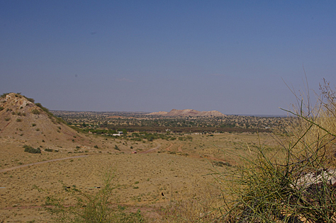
The desert of Rajasthan with the Karentia Hills in the background
The Barmer Basin, India, is a rift of late Mesozoic to Tertiary age representing the onshore northwards termination of the Western Indian Rift System. The sedimentary fill of the Barmer Basin is dominantly continental and Paleogene in age.
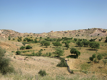
Cropping out on the eastern basin margin, the Cretaceous sediments of the Ghaggar-Hakra Formation contain a dominantly fluvial succession. Preliminary studies (Bowyer, 2004; Clarke, 2011) have identified at least three channel-dominated successions interbedded with significant thicknesses of parallel-laminated siltstones and fine-grained sandstones. The channelised successions, display sedimentary features that suggest that the fluvial systems were dominated by significant variations in discharge and sediment load; hence competence, capacity, sediment supply and climate may be dominant controls upon the texture and architecture of the facies.
The dominantly fine-grained and parallel-laminated successions preserved between the channel-dominated strata may well represent overbank and palaeosol development, although their relative thicknesses compared to the channel-dominated successions are somewhat anomalous, making their relationships to the remainder of the Cretaceous succession equivocal.
References cited
Bowyer, S. 2004. RJ-ON-90/1 Contract area: Integrated field geology report. Cairn Internal Report ED/RJ-ON-90/GEO/04/1504
Clarke, S. M. 2011. Outcrop studies in the Barmer Basin: The Sarnu & Karentia hills, the Barmer Hills & the Fatehgarh Ridge. Commissioned report on behalf of Cairn India PTY. Keele University, Staffordshire.
Steven A. Rogers
Pennsylvanian carbonate mud mounds from the sub-aerial to sub-marine transition along a tilted foreland basin, Cantabrian Mountains, Spain.
Supervisors : Dr Michael Montenari, Professor Graham Williams
Carbonate mud mounds from the Pennsylvanian aged San Emiliano Formation (Cantabrian Mountains, Spain) are commonly well exposed. The mounds range from 2 to 50 m in height and were observed to be primary geological features.
Microfacies, ultrafacies, palaeontological and geochemical studies have revealed the composition of the mounds and surrounding carbonates. The factors and controls of mound nucleation, growth and demise have been established. The mounds are skeletal-microbial pack-wackestones. Peloidal, homogenous and clotted micrites are the main sedimentological constituents of the mounds.
Microfossils are dominant with Donezella, Claracrusta, Rothpletzella and Girvanella being common. Small foraminifera, bryozoans, corals and algae are all present within the mounds, but are more common within off-mound carbonates. The mounds show evidence of deposition within shallow water environments, which may have been periodically sub-aerially exposed.
The formation of the mounds was controlled by a dynamic relationship between Donezellacean algae, and microscopic encrusters. Fluctuating environmental conditions lead to the alternate dominance between the two groups, resulting in accretion and stabilisation of carbonate muds. Off-mound carbonate sediments generally show more evidence for deeper, and in some cases, higher energy environment of deposition. These carbonates are generally packstones, and two distinct types occur: a Donezella dominated carbonate with ooids, and a cyclical micrite-marl sequence which is dominated by ‘phylloid’ algae, bryozoans and corals.
Comparable mounds from the Lois-Cigüera Formation, of the local Bernesga Valley, were deposited in a deeper environment. A relationship between Donezella, Claracrusta, Rothpletzella and Girvanella was not observed within the mounds of the Lois-Cigüera Formation. These mounds are compositionally different to their San Emiliano counter-parts. The San Emiliano Fm. was deposited on the sub-aerial to sub-marine transition on a tilted foreland basin. Carbonate and mound deposition took place within a basin during periods of heightened tectonic activity. Carbonates of the San Emiliano Fm. were originally aragonitic. Three new fossil species are presented.
Andrew J. Bladon (2015)
The early-stage structural evolution of the Barmer Basin rift, Rajasthan, northwest India
Supervisory Team: S. M. Clarke1, S. S. Egan1, S. D. Burley1 & 2, N. Whiteley2, V. Kothari2, P.Mohapatra2
1 Basin Dynamics Research Group, Keele University, Keele, Staffordshire, ST5 5BG, U.K.
2 Cairn India PTY, 3rd floor, Vipul Plaza, Sun City, Sector 54 Gurgaon 122 002, India
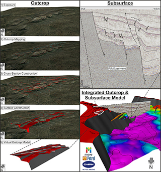
Despite being a significant structure within the West Indian Rift System (WIRS), and an important hydrocarbon province, the structural geology and evolution of the Barmer Basin rift remains relatively poorly understood. The current understanding of rift evolution is based predominantly upon subsurface datasets, where an abundance of complex structures and rift-oblique faults are variably imaged on seismic data throughout the rift. However, the origin of these structures remains elusive, and limited exposure of the structure and stratigraphy of the rift at outcrop has restricted outcrop-based studies. Combined, the findings of outcrop and subsurface studies provide insights into the early-stage structural evolution of the Barmer Basin rift, and present critical data representing regional tectonic processes hitherto unrecognised.
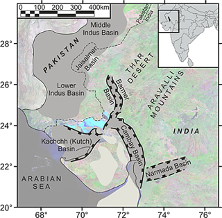
The rifted north-western margin of India, active since the early Mesozoic Era, remains poorly understood despite many hydrocarbon discoveries. Onshore rift basins within the West Indian Rift System include the Kachchh (Kutch), Cambay, and Narmada basins. The Barmer Basin is the most northerly rift within the WIRS and is a long, narrow, and deep (200km, <40km, & ≤6km respectively), late Cretaceous to mid-Eocene, low strain (1.2≤β≤1.5), failed continental rift, that is linked with the Cambay Basin to the south via the poorly defined Sanchor sub-Basin. Together, the Barmer and Cambay basins form a north-northwest trending rift system that extends some six-hundred kilometres into the Indian Craton. To the north of the Barmer Basin, the Jaisalmer Basin forms the eastern slopes of the larger Indus Basin. The Barmer and Jaisalmer basins are separated by a basement structural high, the Devikot Ridge.
Rift-basement rocks in the Barmer Basin comprise the Precambrian Malani Igneous Suite. Unconformably overlying the Malani Igneous Suite, exposure of the Jurassic Lathi Formation in the north Barmer Basin (Fatehgarh Ridge), and the Lower Cretaceous Ghaggar-Hakra Formation along the central eastern rift margin, indicates that deposition occurred in the Barmer region prior to the main Barmer Basin rift event. The syn-rift sedimentary succession in the Barmer Basin is predominantly Paleocene to Eocene in age, and indicates a relative increase in water depth, with a progression from fluvial, through lacustrine, to shallow marine deposition.
This study focuses on the detailed sedimentological and structural analysis of exposures along opposing rift margins of the Barmer Basin, in the Barmer and Sarnoo hills. Subsequently, the findings of outcrop-based work are complemented with freshly interpreted subsurface data to understand and characterise structural complications within the rift. The findings aid exploration in the Barmer Basin, and exhibit how inheritance of pre-existing structures can affect continental rift evolution.
|
|
| Larger Image | Larger Image |
Amy Gough (2015)
Controls of sediment architecture and deposition in arid continental basin margin systems
Supervisors: Dr S.M. Clarke, Dr J.K. Pringle, Dr A.E. Milodowski, Dr P.C. Richards.
Funding: BGS: Permo-Triassic reservoirs and storage cross-cutting project, NDA & Keele University.
Alluvial fans are key environments in continental basins. Their facies and architecture are influenced by the interaction of variable fan environments, climatic cyclicity, changes in base level and the extent of sediment supply. The majority of these controls are cyclically variable, which leads to fans hosting both potential reservoirs and seals. In addition to this, fans are long lived throughout basin development and therefore interact with changing distal environments. An understanding of fan architecture in response to changing controls is crucial to interpreting both fan reservoir potential and fan influence on fluid migration within the basin as a whole.
By studying the well-exposed deposits of the Permian Cutler Group in Utah, U.S.A the complex styles of sedimentation and interaction can be determined, and the findings applied to lesser-exposed alluvial deposits in a bid to understand how the system may affect fluid flow through proximal continental basins.
Thomas A. Randles (2015)
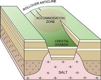
Structure and geometry of accommodation zones in host and supra-jacent sediments associated with the collapse of salt anticlines
Supervisory team: Dr. Stu Clarke1, Dr. Phil Richards2, Prof. Graham Williams1, Sue Stoker2.
1 Dept. Earth Science & Geography, Keele University, Staffordshire ST5 5BG.
2 British Geological Survey, Murchison House, Edinburgh EH9 3LA
Project Summary:
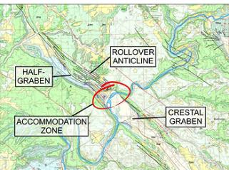
Linear structures associated with salt diapirism, such as salt walls, salt anticlines and salt rollers, are common features in active hydrocarbon provinces including those of the UK North Sea, the West African Salt Basin and the Gulf of Mexico. They often present a wide range of structural styles along their lengths, with complex fault geometries which can be difficult to interpret meaningfully from seismic survey. Salt walls are known to end rather abruptly, or change their dominant deformational style over short distances, resulting in extremely complex accommodation zones where displacement is transferred between the different structural regimes. Given the potential for salt to provide both stratigraphical and structural closure to any reservoirs, and the importance of accommodation zones in offering migration pathways into potential trapping structures, understanding the complexity of salt-related accommodation zones is of paramount importance to the evaluating and risking any related hydrocarbon traps.
In key areas within the Paradox Basin, Utah, U.S.A., horst and graben deformational styles along, and adjacent to, the crests of salt walls give way to half-graben geometries, where displacement is accommodated on a single listric fault with an associated rollover anticline, over no more than a few hundred metres. Hanging-wall structures in these areas have been identified as exhumed palaeohydrocarbon traps, and it has even been suggested that charge may have been by way of accommodation zones. These exposures offer an ideal opportunity to evaluate the complexity of these salt-related accommodation zones, to compare them to geometries resolvable on seismic survey, and to assess the implications they might have for hydrocarbon migration and entrapment.
|
|
|
Geological map of the Moab-Spanish Valley, Utah (Utah Geological Survey, Map 180). |
Geological map of the Moab-Spanish Valley, Utah (Utah Geological Survey, Map 180). |
Aims and Objectives:
- Evaluate the 3D geometry of fault systems, sediment bodies and small scale deformational structures within complex salt-related deformation zones between opposing structural styles using excellently exposed examples from the Paradox Basin, Utah, U.S.A.
- Develop 3D summary models of structural styles present both immediately adjacent to and within those accommodation zones, that can be used to aid modelling of potential hydrocarbon traps from seismic data.
- Apply this field-based modelling to sub-surface analogues for the Utah exposures using well-imaged 3D seismic data from the Central North Sea.
- Develop 3D stochastic flow models for fluid migration through salt-related accommodation zones as a means of evaluating those parameters and uncertainties of the accommodation zone that effect hydrocarbon charge and trap risk.
- Elucidate the controlling-factors on the locii of accommodation zones within salt-controlled basins; What parameters control their position?
Preliminary Work:
Early work has focused on the three-dimensional geometry of sub-seismic scale fault systems in the rollover anticline of a large listric fault, which forms a half-graben geometry at the crest of the Salt Valley salt anticline, Cache Valley, Arches National Park, Utah. Preliminary results suggest a possible link between the development of en-echelon (stepping) hanging-wall fault systems and variation in displacement along the length of the listric fault.
Tim Ferriday (2014)
Chemostratigraphical characterisation of lower Silurian black shales from the Formigoso Formation (southern Cantabrian Mountains, Spain)
Supervisors : Dr Michael Montenari and Professor Graham Williams
Funding: Acorn/EPSAM
The Silurian black shale deposits of the peri-Gondwanan region are one of the most important Palaeozoic source rocks for hydrocarbons world-wide (Lüning et al, 2000). Despite intensive research, questions regarding the genesis and the palaeoenvironmental and palaeogeographic factors controlling the deposition of these shales are a matter of ongoing debate.
The project area lies within the Cantabria-Asturias Arc of Northern Spain in the autonomous region of Castilla y León. The Cantabrian Arc formed as a result of the collision between Gondwana and Laurussia during the formation of the supercontinent Pangea. The Cantabrian Arc has been divided into five major tectonostratigraphic zones. The ‘Folds and Nappes’ zone is of a particular interest especially the Somiedo-Corecillas thrust system.
This work focuses on the deposition of the Silurian black shales of the Formigoso Formation (Fm) within the Somiedo-Corecillas unit. An in-depth palaeoenvironmental reconstruction combined with the high resolution biostratigraphic and chemostratigraphic data will provide new insights into the sedimentation and deposition of the Formigoso Fm. There is an abundance of graptolite fauna within the Formigoso Fm especially towards the base. These graptolites will be used alongside chitinozoan and acritarch data to determine marker horizons laterally within the Cantabrian Arc. Geochemical analysis of the Formigoso Fm will be utilised on a 25cm resolution to determine chemical signatures.
Thickness changes within the Formigoso Fm are dramatic, from metres to several hundred metres in total thickness. The thickness of the Formigoso Fm is seen to increase significantly from the south to the north of the Cantabrian Arc. The lateral changes in thickness are related to a combination of extensional tectonics during the rifting of Gondwana plus erosional processes of the Late Ordovician Hirnantian glaciation.
|
|
Future work aims to define the nature of the contact and lithologies present between the underlying Cambro-Ordovician Quartzite of the Barrios Fm and the base of the Formigoso Fm and this will be used to determine the Rheic (Cantabrian) basin architecture during the initial deposition of the Formigoso Fm.
A comparison of the results of this research and datasets available from Silurian black shale deposits across the northern margin of Gondwana will provide an advanced understanding of the factors controlling the deposition and genesis of the Silurian black shales of the Cantabrian region.
Rosie A. Smithells (2014)
A comparison of the geological, geodynamic and eheological eveolution of the northern and southern Rockall Trough; a numerical modelling approach
Supervisors: Dr Stuart Egan (Keele), Dr Stuart Clarke (Keele) and Dr Geoffrey Kimbell (British Geological Survey)
The aim of this project is to apply and develop 3D numerical lithosphere-scale modelling techniques, combined with the analysis of geological and geophysical data, in order to determine the interplay of geological, rheological and geodynamic processes that have controlled the evolution of the Rockall Basin, NE Atlantic margin. The modelling will be used to test different hypotheses regarding the timing and nature of extensional and compressional events, and the influence of thermal anomalies, and spatially and temporally varying lithospheric rheology. This project aims to exploit a combination of the geodynamic modelling facilities and expertise at Keele University and the extensive knowledge of the geology and geophysics of the NE Atlantic margin at BGS.
Helen M. Doherty (2014)
The Rheic and Palaeotethys Oceans : Palaeozoic evolution of the Northern Gondwana Margin in the North Spain and related areas
Supervisors : Prof G.D. Williams and Dr M. Montenari
Funding: NERC and Keele University
Background Information:
 The northern edge of Gondwana had been dominated by the Cadomian Orogeny during the Ediacaran Period. This orogeny formed a Cordillera-type volcanic arc where oceanic crust subducted below Gondwana. When the mid oceanic ridge was subducted under an oblique angle, extensional basins developed along the northern margin of Gondwana.
During the late Cambrian to early Ordovician these extensional basins had evolved into a rift running along the northern edge of Gondwana. The rift proceeded to evolve into a mid oceanic ridge that separated small continental fragments such as Avalonia and Carolina from the main Gondwana landmass.
As Avalonia drifted north from Gondwana the Rheic Ocean grew. By the late Devonian, the Rheic Ocean had become a narrow ocean that was sutured between Gondwana and Laurussia.
The ocean closed from east to west, first in Central Europe (Hercynian Orogeny) the northeast of North America (Alleghenian Orogeny), northwest of Africa and finally in the southeast of North America (Ouachita Orogeny) and north of South America.
Aims:
I aim to integrate a field based study with basin modelling techniques.
The main geological focus is on the structure of relevant field areas (mainly Iberian). This should make it possible to characterise/define the period of rifting in the north of Gondwana, during the late Cambrian to Early Ordovician through the generation of the Rheic Ocean lithosphere.
This has been controversially reviewed within literature.
Michael J. Kelly (2014)
Cross-strike discontinuities and kinematic linkages within the Moine and Cantabrian thrust belts
Supervisors: Professor Graham Williams (Keele), Dr Stuart Clarke (Keele) and Dr Graham Leslie (British Geological Survey)
Project Rationale:
 Fold-and-thrust belts are intensely studied features of mountain belts around the world, with numerous papers reporting on geometry, kinematics, mechanics and hydrocarbon potential (Mackay et al., 1994). While many have dealt with palinspastic reconstructions and balanced cross-sections parallel to the transport direction; far fewer have focussed on three-dimensional (3D) architecture of fold-and-thrust belts, and how lateral variations in thrust architecture in different segments of a thrust belt are linked via so-called ‘transverse zones’ (e.g. Drahovzal and Thomas 1976; Mitra 1988; Thomas 1990; Brown et al., 1997).
Causative structures for lateral changes are often concealed and not fully studied, however, systematic alignment of these lateral structures have been suggested to include sub-décollement basement faults, pre-thrusting deformation of cover strata above basement faults, the development of duplex structures and antiformal stacks, and/or along strike variations in mechanical stratigraphy (i.e., Harris 1970; Wheeler 1980; Woodward 1987; Thomas 1990; Álvarez-Marrón 1995; Pérez-Estaún et al., 1997; Kollmeier et al., 2000; Thomas and Bayona 2002).
Oblique ramps and transverse zones in thrust belts have been modelled using sand boxes (e.g. Calassou et al., 1993) and numerically (Wilkerson et al., 1991), whilst 3D visualisations and interpretations of thrust geometries have also been computed (e.g. Hinsch et al., 2002; Gorney et al., 2007), but not fully interpreted over transverse zones.
In this work the detailed three-dimensional topology, geometry and kinematics of selected thrust systems will be studied in order to fully analyse their evolution and to examine the cause and effect of lateral changes in thrust belts. The project methodology will incorporate new studies of two well-understood and comprehensively mapped thrust belts; the Achnashellach Culmination / Loch Maree region of the Moine Thrust Belt and the Somiedo-Correcillas Unit of the southern Cantabrian Arc. These will also be compared against classic Appalachian transverse structures within the Anniston, Bessemer and Harpersville Transverse Zones in Alabama, U.S.A.
Aims and Objectives:
 This project will study; detailed geometry of thrust systems in three-dimensions (3D) (geometry); how thrust units and thrusts link together and relate to each other; what these linkages (topology) mean in terms of lateral changes in thrust sheets; how, thrust systems evolve over time (kinematics) – in each case integrating the field and 3D model interpretations.
Three-dimensional models of complex thrust belts are rare, and have not in general been restored to analyse the kinematics of the thrust system. Full, sequential restoration of 3D thrust models will characterise the pre-thrusting template and will assess that template capacity to control subsequent lateral thrust geometries.
This will incorporate field based studies within the Achnashellach Culmination / Loch Maree Fault in the Moine Thrust Belt, NW Scotland and the Somiedo-Correcillas unit in Cantabria, Northern Spain and classic Appalachian transverse structures within the Anniston, Bessemer and Harpersville Transverse Zones in Alabama, U.S.A.
Linda Austin (2014)
The geology and geodynamics of the Northumberland Trough Region: Insights from mathematical modelling
Supervisors : Stuart Egan1, Stuart Clarke1 & Gary Kirby2
1Earth Sciences and Geography, School of Physical and Geographical Sciences, Keele University, Keele, Staffordshire, ST5 5BG, United Kingdom.
2British Geological Survey, Kingsley Dunham Centre, Keyworth, Nottingham, NG12 5GG United Kingdom.
The numerical modelling of the interaction of geological and geodynamic processes has proved to be a valuable tool for explaining the causes and magnitude of regional subsidence and uplift in response to continental tectonics. In particular, geodynamic modelling can be used to investigate the effects of deep processes that are poorly constrained by subsurface and surface data. In this work, we apply 2D and 3D numerical modelling techniques, combined with the analysis of surface and subsurface data, to investigate the structural, stratigraphical and geodynamic evolution of the Carboniferous block and basin structure of northern England. Two dimensional and three dimensional mathematical modelling techniques combined with the analysis of surface and subsurface data have been applied and developed to investigate the structural, stratigraphical and geodynamic evolution of the Northumberland Trough Region. In particular, to provide insights into the importance of deep processes, such as depth-dependent extension, and how they interact with basin-controlling processes such as sedimentary infill.
|
|
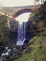
|
| Ashgill Force | Carshield Valley | Cawfields Quarry |
Kevin Podmore (2013)
Fluid flow in the Sub Andean fold and thrust belt, Bolivia
Fluid migration in thrust zones has received considerable research attention because of the effect that focussed fluid flow may have on overpressure development, heat flux and thrust movement. This has implications for society because fluid migration may trigger earthquakes and fluid migration pathways control the accumulation sites for hydrocarbons and precipitation loci for economic mineral deposits. A true 3D structural model incorporating fault zone processes has been implemented by a previous PhD student (DR S Clarke), which enables fluid migration to be modelled contemporary with fault displacement.
Fluid migration within thrust belts has been investigated by several different studies. There are two proposed mechanisms for the migration of hydrocarbons into traps. The first concerns a topographic head i.e. shallow meteoric water drive, and has been applied to examples within the Himalayas and Canadian Rockies. Tectonic compaction forms the basis for the second mechanism, with the drive coming from deep, hot fluids within the thrust belt itself as applied to the Alpine area and Sub Andean thrust belt. There is however no consensus for a generic drive as different thrusts examples may favour a particular drive.
The aim of this study is to use a BG structural datasets of existing fields in Bolivia to understand the geometry and thrust kinematics within the area. It will be necessary to extract the data from GeoFrame in a format that will allow the data to be modelled within Keele's 3D structural modelling and fluid migration software. The existing software will require further development to allow the simulation of thrusting and compressional deformation involving lithological juxtapositioning and shale smear and fluid flow using invasion percolation techniques. Outcrop and core studies in Bolivia of related thrust zones will be used to substantiate model results in order to fully characterise their nature. To further assist with the modelling a series of 1D temperature/maturation models will be constructed to generate a series of boundary parameters.
BG is the second largest holder of gas reserves in Bolivia with eight large exploration/exploitation blocks and participates in Itau and Margarita, two of the largest discovered gas fields in Bolivia. Overall, BG estimates that it has over 4 tcf of equity gas reserves in Bolivia.
|
|
|
|
Richard B. Haslam (2012)
3D geological modelling of superficial deposits, bedrock stratigraphy and fracture networks, Dounreay, Scotland; implications for subsurface contaminant pathways
Any industrial site producing contaminants (including chemical and radiological materials), will be constructed on or below the surface, whose associated properties determine how fluid and contaminants travel. The Dounreay Nuclear Power Establishment offers a unique opportunity to understand bedrock geology, superficial deposits, shallow fractures, and their controls on fluid and contaminant pathways. This is due to its complex history, possible contaminants and extensive
prior site investigations.
Three-dimensional geological modelling is becoming an integral part of site investigations as affordable technology becomes more powerful. Using previously collected, data and state-of-the-art modelling, a high-resolution geological model has been created based on understanding the cyclicity of the Devonian sedimentation of the Orcadian Basin. This underlies the site providing a framework for discrete fracture network and stochastic facies modelling. A discrete fracture network, for three fracture sets, has been created for the bedrock geology through statistical analysis of scanline and borehole data, and stochastic simulations of fracture intensity throughout the geological model. Due to the heterogeneity of the superficial deposits, a stochastic simulation was used to interpolate five distinct superficial facies, considered to influence contaminant pathways and identified from geotechnical logs; 1–Clay, 2–Sand, 3–Gravel, 4–Silt and 5–Peat.
Fracture intensity of the hydraulically conductive bedding-parallel fracture set decreases logarithmically with increasing depth. The decreasing fracture intensity of the bedding-parallel fractures reflects a decreasing horizontal hydraulic conductivity, which at 100m levels off and becomes approximately equal to the vertical hydraulic conductivity. The superficial deposits are predominantly clay, with the maximum hydraulic conductivity associated with the gravel facies. The gravel facies provide connectivity from the land surface to the bedrock and associated fracture networks. Methodologies used here can be applied to any site investigation, providing adequate data is available, and by integration, analysis and three-dimensional modelling of the shallow subsurface, a better understanding of contaminant pathways and uncertainties can therefore be achieved.
Oliver J. W. Wakefield (2010)
Aeolian, fluvial and shallow marine sedimentology system interactions in the Permian Cutler Group, southeast Utah, USA
Supervisors: Nigel Mountney, Stuart Clarke & Jamie Pringle
 While desert systems have been the subject of numerous studies, little work has been focused expressly on ‘linked depositional processes’ or interactions with aeolian and non-aeolian processes, other than the works done by Langford (1989), and Langford & Chan (1989). This project aims to improve our understanding in such ‘linked depositional processes’ by studying the sedimentary expressions of interactions formed by competing aeolian, fluvial or marine processes.
This project uses ancient case studies of the Lower Cutler Beds, the Cedar Mesa Sandstone and the Organ Rock Formation which are successions present within the Culter Group. The Cutler Group is exposed in the asymmetric foreland basin of the Canyonlands National Park, south-eastern Utah, and is widely recognised as a group of sedimentary successions that were deposited in arid to semi-arid environments. The case study examples show clear evidence of arrays of interactions between aeolian, fluvial and marine processes, both contemporaneous and time-independent in nature.
Many of the types of interaction inferred from the Cutler Group are widely recognised within other ancient successions and within present-day desert systems. Because of this, the criteria for the recognition and prediction of styles of aeolian, fluvial and marine interactions have applied implications, given that resultant facies configurations exert a primary control on stratigraphical heterogeneity and compartmentalisation within hydrocarbon reservoirs. As a result, this study aims to address unresolved issues in potential hydrocarbon reservoir compartmentalisation, barriers and baffles, through detailed stratigraphical and sedimentological analysis.
Preliminary results show numerous interesting interactions that vary on both size and position within the larger depositional environment. Examples of small scale interactions include;
- small scale-reworking of aeolian deposits by fluvial channels,
- ‘accessory flooding’ within enclosed interdunes depressions, resulting from a rise of the water table due to influx of water by fluvial systems.
Larger scale examples of interactions include;
- regionally correlatable aeolian supersurfaces capped by overlapping fluvial channel complexes,
- marine transgressions: Thin, large extensive sheets of marine strata from marine transgressions overlying fluvial and aeolian sediments.
Studying interactions within the Cutler Group further augments our knowledge of desert environments and marginal marine (littoral) settings, but also has an applied edge in aiding the generation of more precise reservoir models.

|
|
|
BSRG Abstracts 2006-2008
- BSRG 2006 Preserved Sedimentary Expression of an incised valley-fill sucession within a transgressive shoreline system; Cutler Group, Paradox Basin, Southeast Utah, USA. BSRG 2006 poster and BSRG 2006 abstract
- BSRG 2007 Contrasting styles of aeolian, fluvial and marine interaction in the Cutler Group of the Paradox Basin SE Utah, USA. BSRG 2007 poster and BSRG 2007 Abstract
- BSRG 2008 Modelling the 3D Stratigraphic complexity inherent in mixed fluvial-aeolian successions : examples from the Pennsylvanian to Permian of Southern Utah, USA. BSRG 2008 Poster and BSRG 2008 Abstract.
Stephen Cain (2009)
Sedimentology and stratigraphy of a terminal fluvial fan system; the Permian Organ Rock Formation, South East Utah
The Permian (Wolcampian) Organ Rock Formation constitutes part of the Cutler Group within the Paradox Basin of southeast Utah . The Organ Rock Formation has received very little detailed attention, despite its potential for detailed architectural work. The style of sedimentation seen within the succession is of a type not previously studied in detail, exhibiting abundant loessite deposits and the autocyclic reworking of calcrete palaeosols (calcisols) via flash-flood processes.
This project will present novel research on aspects of continental sedimentology not yet looked at in any detail. It will therefore, not only help to further the understanding of continental stratigraphy and sedimentology, but it will also give recognition to this relatively unknown and potentially exciting stratigraphic succession.
An initial two week reconnaissance trip was made to southeast Utah during October-November 2005. Thirteen one-dimensional sedimentary logs totalling nearly 1.5 km in length were acquired along northeast-southwest transect approximately 140km long, recording the proximal to distal transition within the system.
This early work has enabled the construction an initial region stratigraphic framework to a level of detail not hitherto attempted. The Organ Rock Formation represents a terminal alluvial fan system, which passes distally into loess and wind-blown deposits. The fan surface experienced repeated stabilisation and subsequent reworking by fluvial processes indicated by calcrete palaeosols and channel-fill complexes containing calcrete conglomerates. Spatially, the Organ Rock Formation displays considerable lateral variation. Temporally, ten erosively-based fining upward cycles form an overall fining upward trend and the retrogration of coarser-grained clastic sediments back towards the source area to the northeast.
Alison Jagger (2003)
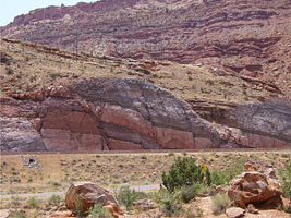
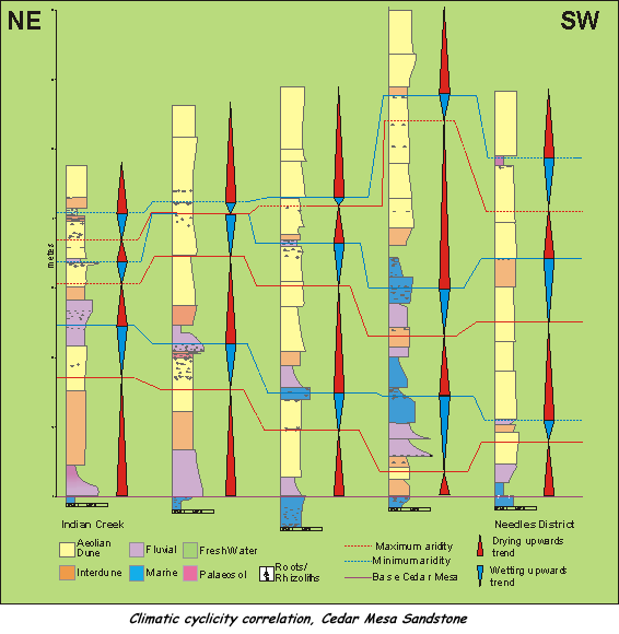
Sedimentology and stratigraphic evolution of the Permian Cedar Mesa Sandstone, Paradox Basin, SE Utah
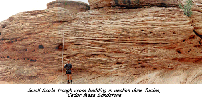
Within the study succession at least three main drying-upward cycles are recognised which are superimposed on an overall drying-upward trend. The sedimentary expression of the cycles varies across the region. In the northern area each cycle is characterised by an upward transition from fluvial-channel, through fluvial sheetflood to aeolian sandsheet and dune environments. This succession is interpreted as representing the waning flood of an ephemeral fluvial system, followed by abandonment and aeolian reworking. Further south, towards the erg centre, preserved cycles are more subtle, with relatively humid episodes being characterised by interdune flooding events, palaeosol development and the stabilisation of the dune field by vegetation (rhizolith horizons). By contrast, relatively arid episodes are characterised by thick cross-bedded dune sets with associated dry interdune deposits. Although the varied facies expression encountered within the study area makes traditional lithostratigraphic correlation difficult, the recognition of cycles controlled by regional changes in climate provide the basis for a chronostratigraphic correlation technique.
Matthem A. Farris (1999)
Sedimentological controls on palynomorph preservation, Triassic red-bed facies, UK Central North Sea and West Midlands
The preservation of sedimentary organic matter (SOM) has been studied from Triassic red-bed facies in the Central North Sea and West Midlands. Mode of preservation is associated closely with sedimentary facies. Additionally preservation in the Skagerrak Formation also exhibits a regional control that may reflect differing early diagenetic regimes associated with depositional environment. Where controls on the preservation of SOM are understood, facies-based sampling improves successful recovery and reduces the cost of biostratigraphic study.
Triassic fluvial red-bed sediments form significant hydrocarbon reservoirs in the Irish and North Sea Basins. Development of these plays is hampered by a lack of understanding of the stratigraphic relationships between reservoir sandstones, owing to inadequate biostratigraphic control on correlations. Poor biostratigraphic control is a reflection of inconsistent palynological recoveries and a general deficiency in understanding the differential preservation of palynomorphs in continental red-bed facies: typically c.95% of palynological samples prove barren.Palynological and sedimentary facies analysis has highlighted a relationship between facies and SOM. The prevalent facies in any sequence prove largely devoid of SOM: these include channel sandstones, intraformational conglomerates, and most overbank deposits. Successful palynological yields are associated with channel abandonment fines, thin intrachannel claystone drapes (highest SOM concentrations), and fine-grained interbedded heterolithics that are interpreted as playa sediments. These facies commonly form less than 10% of any cored sequence, and may be lacking.
Detailed sampling within sedimentary units has demonstrated that SOM abundance varies with sediment colour changes. Regionally, successful palynological studies are concentrated within the southernmost part of the Central Graben. Here, in a more distal palaeodepositional setting, channel and playa facies associations are well developed. Further study will investigate whether early diagenesis in the south was influenced by variable water table and pH conditions whereas less productive sections experienced low water tables and oxidative alkaline groundwater. Palynological assemblages from productive sections include diverse riparian floras and this supports the suggestion that high groundwaters must locally have existed in this region, at least periodically.
|
|
|
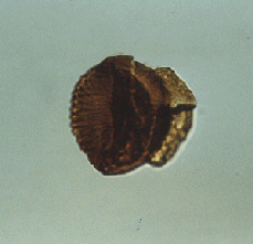
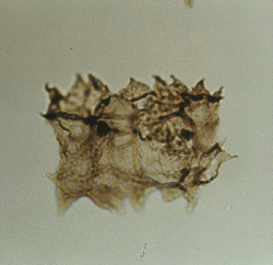
| Vittatina (reworked into Anisian strata from Permian rocks) | S.multistriatus | Plaesiodictyon mosellanum (fresh to brackish indicator) |
Nicholas T. Smith (1998)
The Carboniferous to Mesozoic structural and stratigraphic evolution of the Cheshire Basin, England
Using techniques of seismic sequence stratigraphy the Permo-Triassic megasequence can be divided into three sequences bounded at the top and base by local or regional unconformities. Construction of a seismic sequence stratigraphy allows the examination of the interaction of tectonics and sedimentation. On this basis the Cheshire Basin can be divided roughly into two areas - a westerly area close to the western basin margin and an easterly area nearer to the Wem / Red Rock Fault. Seismic interpretation shows that deposition in the western area was essentially post-rift - resulting in packages of parallel reflectors on seismic data.
In the easterly area the upper two sequences are imaged on seismic as growth sequences represented by diverging reflectors. This supports the present view that the onset of the main phase of fault controlled subsidence began with the deposition of the Chester Pebble Beds Formation (Evans et al, 1993). In this area however, both the two upper sequences are bounded at the base by angular unconformity. The upper unconformity, at the base of the Helsby Sandstone Formation, has been described by previous authors (Evans et al, 1993), and was suggested to be the equivalent to the Hardegsen Unconformity. The lower unconformity at the base of the Chester Pebble Beds is described for the first time here. The current geometry of the reflector packages representing these sequences shows that in both cases part of the sequences lie above a regional elevation. If, on sections where the growth sequences occur, a "null line" representing the transition between net extension and net compression is constructed, the sequences are seen to be in partial net compression. Inversion of the growth sequences above the base of the Chester Pebble Beds is suggested to account for these features.
Higher up in the Permo-Triassic megasequence the application of seismic sequence stratigraphic techniques enables the identification of the widespread halite units within the Mercia Mudstone Group. The bases of both the Northwich and Wilkesley Halite Formations form generally bright reflectors throughout the Cheshire Basin, and are seen to be essentially conformable with underlying sequences. However, in the SW of the Cheshire Basin erosive channel bases are identified for the first time, represented by truncation of underlying reflecto
Nicholas A. Robb (1998)
An integrated structural, sequence stratigraphic and geodynamic analysis of the western Black Sea
The Black Sea has undergone about 15km of subsidence since the early Tertiary. Although the causal mechanism for this subsidence is still not understood at its depocentre, it is commonly considered to be caused by back arc extension related to a subduction zone lying somewhere to the south. This idea however, conflicts with the lack of extensional faults cutting the Tertiary sequence in offshore seismic reflection data.
Current research aims within this project are consequently investigating possible geological and geodynamic mechanisms that may have contributed to the formation of the western Black Sea since the early Cretaceous. These processes may include deep crustal loading beneath the surrounding thrust belts of the Pontides, Balkanides, Crimean Mountains and Caucasus combined with geological processes such as thrusting and associated subsidence and sedimentation.
These objectives are being achieved by interpreting seismic data from oil and service companies to understand the structural and stratigraphic evolution over regions covering offshore Bulgaria (Balkanides and Moesian Platform), offshore Ukraine and offshore Turkey. Seismic interpretation is in part undertaken using Schlumberger Geoquest Charisma workstation. Sequence stratigraphy, burial history modelling using Platte River's BasinMod software, structural restoration modelling using Midland Valley's 2D and 3DMove software and geodynamic modelling of the deep lithosphere are some of the techniques used within the project to understand the processes that have affected the western Black Sea. Fieldwork in Turkey and Bulgaria have provided useful analogues for seismic and well log data.
A fresh sequence stratigraphic nomenclature has been constructed using the seismic and well data. Other important results have included demonstrating that the Black Sea is not a simple late Cretaceous back arc basin and that other processes such as eclogite phase changes within centre of the basin may have brought about much of the subsidence observed. Different structural styles have also been observed across the Black Sea and basement reactivation has played an important role in determining these styles. The Moesian Platform and offshore Ukraine especially have been greatly affected by Tertiary compression from the Balkanides reactivating basement faults. The Balkanides has exhibited hinterland ‘break-back thrusting' and over offshore Turkey, foreland basin signatures have been submerged beneath later subsidence related sediment.
The Late Cretaceous to Late Miocene Stratigraphic and Tectonic Evolution of the Bulgarian Black Sea
The Black Sea contains two basins separated by the mid-Black Sea high. It is widely thought to have opened during the Cretaceous as a back-arc basin behind the Rhodope-Pontide volcanic arc and adjacent Srednogorie volcanic arc linked with the closure of Neo-Tethys. The work presented focuses on the Late Cretaceous to Miocene evolution of the Western Black Sea and the relationship between Tertiary compression within the Balkanides and synchronous lithospheric flexure in the Dolna Kamchia depression.
A combination of both regional and local scale seismic interpretation, well log analysis, burial history modelling and fieldwork has been used to obtain a detailed understanding of the geological evolution of the Bulgarian Black Sea basin. The Upper Cretaceous succession shows increasingly deepwater facies towards the north, away from the Balakanide fold belt that has reactivated early Mesozoic normal faults. Turbiditic sands and muds pass northward into pelagic limestone and marl. Northeast directed pulses of compression continue into the Palaeogene giving rise to thin skinned thrusting that is coincident with the deposition of turbiditic muds and sands to the north that show an overall upwards coarsening. The deformation style in the Eocene flysch has been affected by the competency of lithologies. During the Miocene, silts and muds of a distal shelf environment coarsen upwards into bipolar, cross-bedded, clean sands. Seismic data indicates a northward progradational basin fill during the Miocene. Neogene wrench fault activity has produced positive flower structures that are visible at both field scale and on seismic data.
Comparison with data from the Turkish Black Sea basin and Pontides mountain belt reveals synchronous compression during the Late Cretaceous through to the Oligocene producing dissected foreland basins. Rapid subsidence during the Eocene is observed on offshore seismic data and coupled with Bulgarian observations, suggests that the formation of the Western Black Sea Basin is superimposed upon a compressional foldbelt and foreland basin.
Neogene Sequence Stratigraphic Analysis of the Western Black Sea
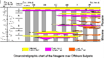
Seismic sequence stratigraphy has revealed an average of eight Neogene sedimentary sequences. Throughout the Neogene, much of the sedimentation observed within the western Black Sea basin has been within a deep marine setting. Pelagic sedimentation, indicated by parallel high amplitude reflectors, represents steady sedimentation within the deeper parts of the basin and is occasionally interrupted by deep fan deposition toward the basin centre. At the basin margins over offshore Bulgaria, Ukraine and Turkey, sequence boundaries within a shallow marine, shelf environment are identifiable and are occasionally resolvable down to systems tract levels. The thickest package of sediment is the sequence immediately overlying a widespread, massive Mio-Pliocene unconformity. This could indicate a widespread drop in base-level during the Messinian, documented within the Mediterranean, creating highs along the basin margins which would source much of the thick lower Pliocene lowstand systems tract sediment.
The number of sequences within TB3 (Upper Miocene-Quaternary of the global sea-level chart) is nine (Haq 1991). Therefore, there is a similarity between the number of sequences identified within the western Black Sea and those of global charts. The Pliocene global sea level chart contains six Pliocene 3rd order cycles and this compares with five over Bulgaria, Turkey and Ukraine. The Black Sea sea-level curve of Ross et. al (1978) is a gross over-simplification of sea level change during the Neogene, since they concluded that sea level minimum was reached during the Middle Miocene with a subsequent sea level increase during the Pliocene. The work presented here shows that the Ross et. al (1978) sea level curve is inaccurate in light of seismic sequence stratigraphical evidence and that instead, there is a close match between global sea level curves and the Black Sea sea level changes observed on seismic data.
Abd E. M El-Fiky (1998)
Aspects of upper carboniferous nonmarine carbonate sedimentology in Central England
This study presents a new hypothesis for the formation of the blackband ironstones which are well known ores in North Staffordshire. The blackband ironstones are a group of thick, fossiliferous, sapropel-rich, finely laminated beds typically developed immediately above the coal seams of the Blackband Formation in North Staffordshire, locally changing laterally to limestones in the western areas of the coalfield. Microscopic studies have shown strong similarities between the textures of the blackband ironstones and their equivalent limestone facies. In both cases, irregular shaped micritic bodies are enclosed within bituminous films, with an overall anastomosing appearance. The other recorded features strongly suggest an algal affinity for these films. In some localities, the first cement phases within the faunal cavities was found to be acicular calcites that were later replaced by siderites. Blackband ironstones on the other hand contain similar d13C values (average of -2 PDB) to those of the calcareous shells extracted from the limestone beds suggesting that the latter provided the bicarbonates. Therefore, the siderites in the blackbands replaced original calcites (or aragonites). The high Mn content here suggests early formation of siderite from Fe-Mn-rich solutions, before significant loss of Mn. In contrast, clayband ironstones display lower Mn and 13C enrichment related to slightly later time of formation.
Compiled geochemical and petrographic data, thus suggests that the iron in the blackband ironstones was introduced to the system at some stage soon after the deposition of these beds that were originally precipitated as limestones. The Fe was thus introduced in the ferrous form through underground solutions. It is suggested here that the laterites that have provided the original detrital materials of the red beds commonly recorded in the studied sequences, may have also provided the initial Fe source. Chemical leaching in these areas under thick vegetative cover (during active formation of potential coal seams in the basinal areas) may release significant Fe and Mn in groundwater solution. Migration of these solutions towards the basinal areas containing bicarbonate-rich sediments (the limestones) will result in supersaturation with respect to siderite, and consequently its precipitation. This explains why the ironstones mainly develop above coal seams.

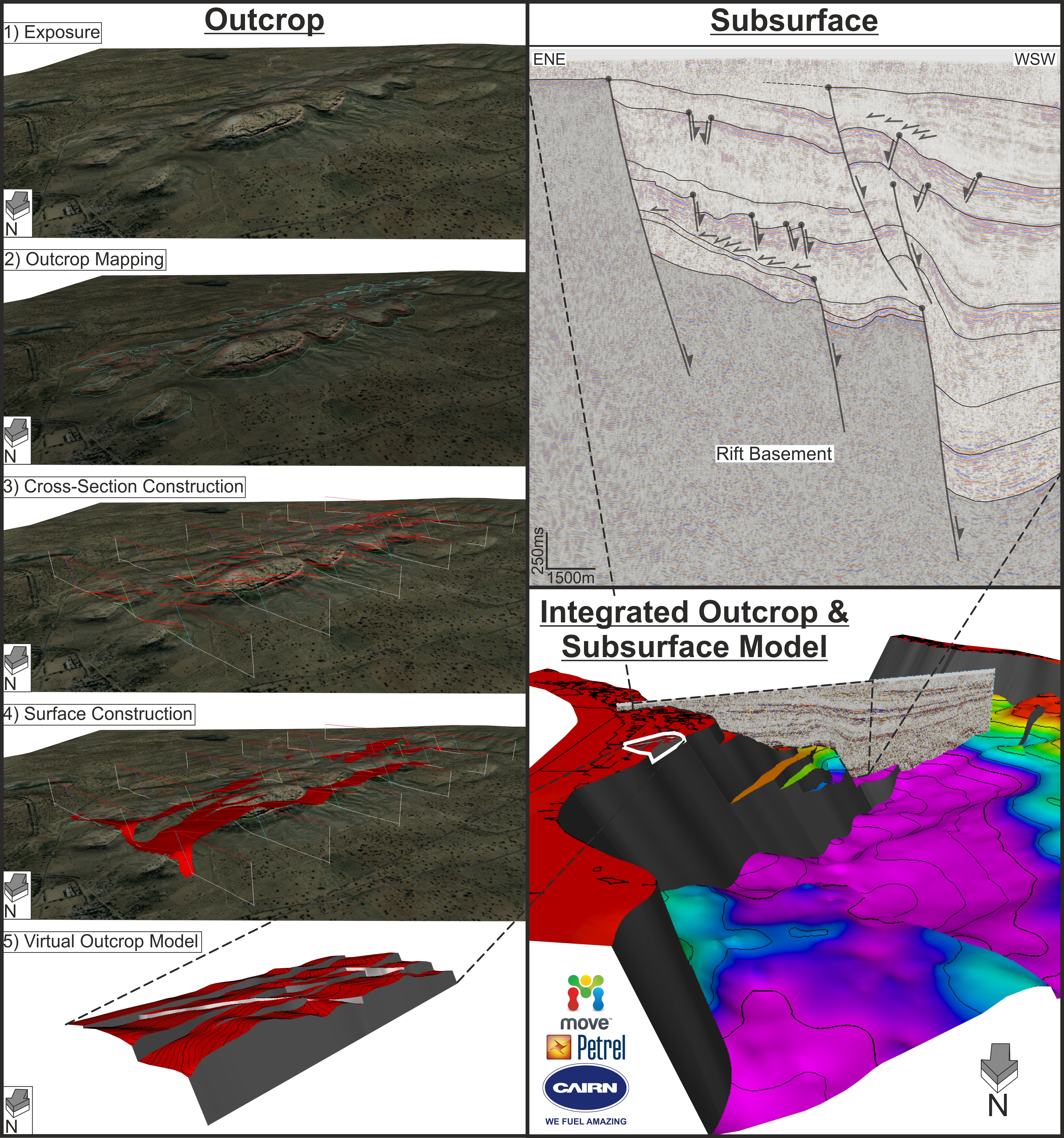
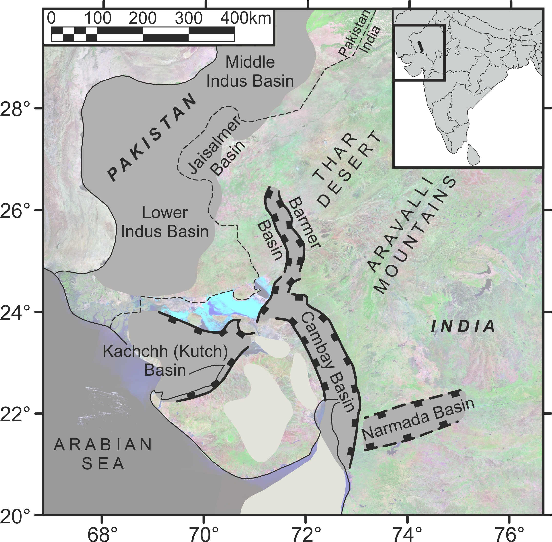
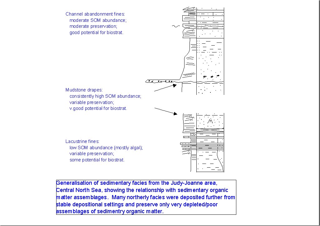