Typical surveys
Mine workings
Two field crew have mobilised to Kalgoorlie, Western Australia as part of the ongoing contract with Kalgoorlie Consolidated Gold Mines to locate and quantify abandoned stope workings within the super-pit. Following the completion of a three-week survey in Horseshoe pit, a further microgravity survey has been commissioned for the adjoining Office Pit located on the -240m level.
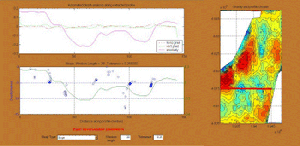
 A further site period of three weeks has elapsed and the data recorded during the Office Pit survey are shown in the accompanying figure. A total of 1800 microgravity stations were observed on an orthogonal 5m grid using two Scintrex CG3-M gravity meters. The precise levels of each station, which were calculated using a spinning laser system, have been input with the Scintrex data and downloaded daily for routine processing and quality assurance.
The first figure shows the raw gravity, as it is output directly from the Scintrex gravity meter. The effects of the Earth Tides, which account for a magnitude of up to 250 microgals, have been removed and the data corrected based on the latitude and longitude of the site and the precise time at which the gravity observation was made. At this stage, the drift of the instrument has been removed from the data during the daily data processing, but no further processing has been carried out. Clearly, the results are of no practical use in identifying any negative anomalies present due to underlying cavities.
Two broad ridges are visible running west to east across the site area. Due to the size of the survey (approximate dimensions of 350m by 200m), three Base Stations were used. Effectively, three surveys, each relative to one Base Station were completed and the removal of the offsets across the site is carried out with subsequent Base Station Ties.
 Gravity decreases with increased distance from the centre of the Earth. Consequently, gravity measured at an observation station will vary according to the elevation of the observation point as well as a direct result of the ground conditions and density contrasts.
We generally use a rotating laser levelling system to facilitate elevation measurements to be made to within 10mm. The initial topographic control has been established by the field crew at the commencement of the survey to a closure of <5mm. Based on these station elevation results, the raw gravity can now be corrected to account for the relative differences in elevation between the 1800 stations. The Free Air Correction is applied to account for the additional height above datum and the Bouguer Correction corrects for the rock actually present rather than ‘free air’.
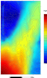
These functions combine to form the Elevation Correction and when this has been removed from the Raw data, in conjunction with the Base Station ties, the Bouguer Gravity Map is created (shown right).
 The Bouguer Gravity map is still of little use in terms of detecting the presence of abandoned stope workings beneath the pit floor. It may have illustrated areas of the survey or even individual points which are erroneous and should be scheduled for re-observation or checking before the field crew demobilise from site.
The Bouguer gravity map is dominated by the effects of regional geology and crustal structure. Furthermore, the gravitational influence of the open pit itself with 250m high walls also overshadows the microgal scale anomalies that we are interested in.
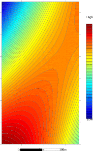
We must now remove these features which dominate the results. The effects of the regional geology and structure are removed by mathematically subtracting a three-dimensional polynomial surface from the data set. Experienced processing ensures that a surface of sufficiently high order is removed to reveal any underlying anomalies, whilst at the same time leaving the anomalies in question intact. The surface to be removed from the observed gravity data set for the Office Pit survey is shown above.
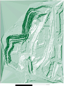 As the survey has been carried out in the bottom of a 250m deep pit, the huge mass of rock comprising the side walls exerts a pull on the gravity meter sensor. In order to remove the effects of the surrounding terrain, a terrain correction must also be applied to the data. This is calculated from a digital terrain model of the whole of the pit. Kalgoorlie undertakes a fly-over of the pit every three months and aerial photography is used to generate a three-dimensional model of the ground. The data is then mailed to us in the UK in x,y,z ascii format. The topography of the open pit is illustrated as a shaded relief plan. The Terrain Correction must account for every cubic metre of the pit as all points around the pit affect each point of the microgravity survey. The Terrain Correction calculated for the Office Pit survey is illustrated in the following step and, incidentally, takes up to 8 hours computing time.
 The terrain correction calculated from the topographic model of the entire pit is shown alongside.
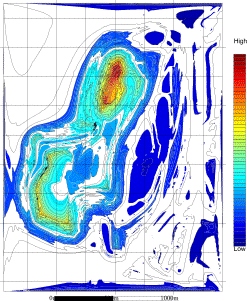
A series of corrections have now been applied to the raw data and the polynomial surface has been subtracted from the raw gravity observations. This involves considerable processing time and resources and indicates the extent of the ‘behind the scenes’ activity that the client generally does not see leading up to the production of the Residual Gravity plan. It is this residual plan that generally forms the first answers to the microgravity application.
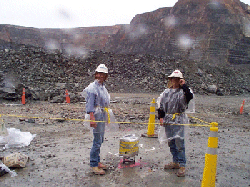
As you can also see - it is not always hot, dry and dusty in the interior of Western Australia when microgravity surveys are undertaken!
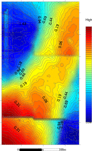
 The data processing is now complete and the final residual plan is shown alongside. The extent of large cavities and associated stopes are clearly visible trending north-south on the plan. Areas of deep blue have been proved to indicate the intersection of several stopes or the formation of large cavities from collapse of the walls and roof rock in particularly worked zones.
The plan shows several significant cavities covering areas of up to 40m wide on the pit floor. The N-S trend of the abandoned gold workings is evident, with the cavities superimposed.
The results of the microgravity survey are imported into the mines’ Vulcan 3D modelling software in order to assess the implications of the stopes and cavities on the future excavation and blasting panels as the pit progresses. Further data processing and modelling may now be used to examine particular areas in greater detail. In the working pit access roads for 200 tonne trucks, face shovels and associated plant must be operational 24 hours a day to maintain production. In several instances, the microgravity surveys have assisted in the routeing of these tracks through the apparent minefield of old workings. Through processes of Euler Deconvolution and the application of Laplacian Operators (which analyse the horizontal gradients of the gravity anomalies in order to better define the edges of features), the depth and location of the stopes can be determined.
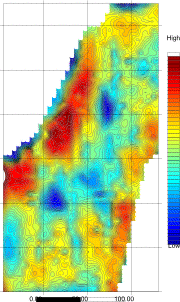
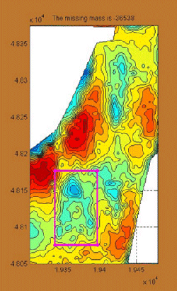 A valuable piece of information is the volume of material that is missing. This “missing mass” is the cause of the negative gravity anomaly and in engineering terms is very useful in the estimation of grout quantities required to remediate a site. In this situation, the size of the feature may be approximated from a knowledge of the volume combined with stope plans and cavity laser surveys. The anomaly highlighted in pink has a missing mass of 36,500tonnes.
In the figure below, a process called Euler Deconvolution has been used to determine the depth to the feature. The mathematical solutions for the depth of the causative body indicate that the stope on the right lies at a depth of approximately 5m while the larger stope on the left is at a depth of approximately 10m.