Applications of microgravity
Aquifer monitoring
Microgravity has been proven to be of value in monitoring the depletion of underground aquifers, not only for water supplies but also for geothermal reservoirs. Considerable work has been conducted in the USA to determine and monitor mass redistribution due to fluid extraction and reinjection. Once benchmarks have been established the aquifer can be monitored over time and the data applied to hydrological models.
Archaeological surveys
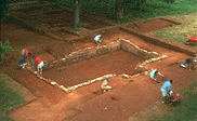 Advances in acquisition techniques now mean that microgravity has become a viable exploratory tool for the archaeologist. As with other applications, the method focuses on missing mass. Therefore, microgravity can and has been utilised in the search for burial chambers and associated tunnels. As the method of data collection is totally passive archaeologists need not fear any form of disturbance over sensitive sites.
Cave & swallow hole detection
 Microgravity is the primary tool used for the location of shallow (<50m) caves and swallow holes. Microgravity is the only surface geophysical method that will provide the location of such karstic features regardless of their shape or fill provided a sufficient density contrast exists. Cavities constitute a considerable hazard to development and redevelopment and any migration to the surface may seriously damage property and services. Such features need to be positively identified prior to any engineering design and construction. Under correct conditions, a microgravity survey can successfully detect and delineate natural cavities.
Coal mine working detection
The same principles for detecting natural cavities can be applied to locating and delineating man-made underground workings. Microgravity has advanced rapidly since the mid-1980’s and is now recognised as the prime method for establishing the presence of shafts, adits and workings. If conducted properly Microgravity surveys are capable of detecting workings to a depth as much as 100m when data is acquired carefully and the information undergoes stringent analysis. Microgravity has been highly successful in the detection and location of abandoned shafts in a wide range of mining environments. In addition, unlike other geophysical methods, microgravity is not susceptible to interference from cultural interference, including traffic.
Environment studies
With the increase in demand for the redevelopment of brown field sites, the determination and location of subsurface features is of considerable importance. Microgravity can and has been applied in the detection of such features (usually combined with other geophysical methods). As early as 1967, microgravity was used to locate buried concrete water tanks and reservoirs. More recently microgravity was utilised in the location of World War II bunkers.
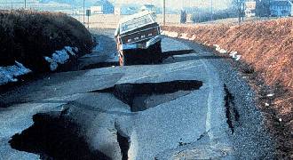
Evaporite dissolution mapping
Both man made mining and natural dissolution of evaporites have caused catastrophic subsidence in various areas of Britain. The rapid dissolution of gypsum has caused £1,000,000 worth of damage and generated problems for planners and engineers. Microgravity has been successfully applied to target drilling and probing investigations. As a result, microgravity has delineated numerous breccia pipes and large cavities that breach or come near to the surface.
Geological modelling
Bedrock formations are typically denser than overlying drift. If the density contrast is significant then bedrock relief can be mapped using Microgravity. The technique is most suitable for studies of bedrock at depths in excess of 50m. In addition, microgravity can be utilised in the mapping of near-surface faulting.
More recent applications are the mapping of potholes within bedrock. Such holes can have significant implications on civil engineering design and construction, for example when a project design requires piling to bedrock.
Hard rock mining
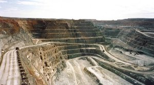 Microgravity has successfully been applied to a number of hardrock mining environments specifically in South Africa, Namibia and Australia. The applications vary from structural mapping, old mine working detection and delineation of sinkholes caused by dewatering. The two last examples have serious safety implications and not only affect the operational side of mining but also the economics of operating in such environments. Microgravity continues to provide support for mining activities aiding in health and safety and production.
Landfill studies
Microgravity has been successfully applied in the delineation of old landfill sites where there is no information on the pit's dimensions. The success of the method can be attributed to the significant density contract between domestic refuse and the underlying strata. A number of profiles across the site can result in the accurate mapping of the base of a landfill and aid in any future remediation.