Freeport, Grand Bahama - a microgravity case study
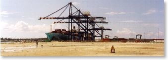 Phase 2 of the Freeport Container Terminal lies adjacent to the existing port. Shallow dissolution cavities were thought to underlie the site so we were commissioned to undertake a Microgravity survey.
A total of 6850 gravity stations were observed within a tight program of 37 acquisition days. The residual gravity plan revealed an extensive cave system, shown on the plot as a system of sinuous blue and green negative gravity anomalies. 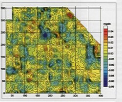 Approximately 30% of the site was shown to be underlain by cavities. In addition to the main quay and container storage area illustrated to the left, two further areas were surveyed as part of the ongoing expansion plans for the Terminal.
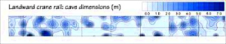
A comprehensive interpretation revealed the depth, shape and mass deficiency of the cavities. This permitted the calculation of grout quantities required to stabilise the site. Subsequent 3D modelling enabled contour plots of cave dimensions to be created for critical engineering areas. The figure below shows the cave dimensions along the proposed crane rails. The largest anomaly was caused by a cavity with a proven height of 6 metres with associated passages.
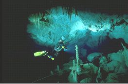 Novel ground truth was obtained from a cave dive survey that proved caves and passages directly beneath the gravity anomalies. A total of 48 probe holes were drilled across the site to confirm the depth and extent of cave system. These showed a very close correlation between the gravity models and actual cavities.